How big are the California wildfires? Almost as big as Sioux Falls
Five California wildfires engulfed roughly 55 square miles
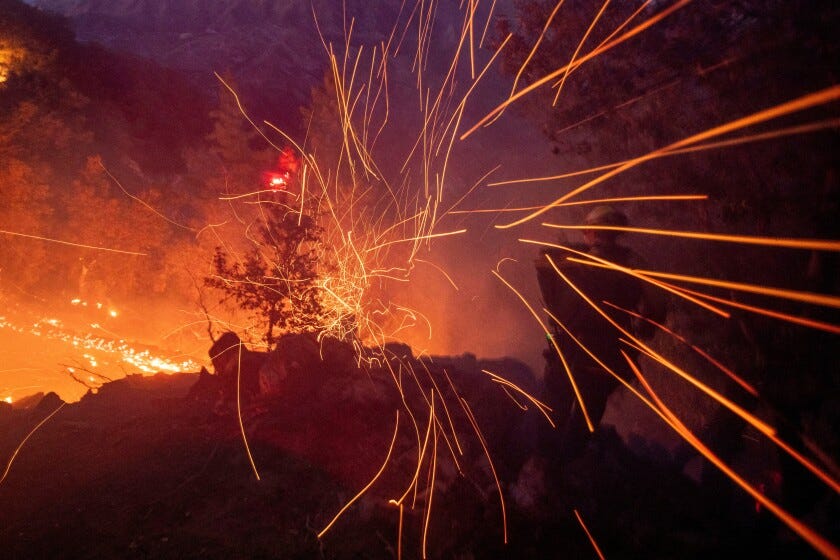
Four days after a fire began outside Los Angeles, firefighters continue to fight a series of damaging and deadly blazes across southern California.
With five named fires currently burning, at least 10 people have been confirmed dead by what officials are saying is likely to be the most destructive wildfires in California history.
More than 180,000 people remain displaced from their homes as thousands of structures have been destroyed.
Sioux Falls gets $13M breakthrough on Arrowhead Parkway-Veterans Parkway overhaul
Sioux Falls taxpayers won’t be footing the bill to build what will be the largest intersection in the state all by themselves after all.
The series of fires, burning primarily to the west and north of Los Angeles proper, still haven’t been fully contained, with four named fires at 10 percent or less containment, per Cal Fire. The fifth fire, one the smallest actively burning, has been 60 percent contained.
With the fires burning so far from our homes, it can be difficult to grasp the sheer size of the blazes.
According to data released by Cal Fire, the five named fires had engulfed just over 55 square miles of the greater Los Angeles area as of 9 p.m. Thursday, Jan. 9.
Living so far away from California, it can be difficult to understand just how much land that is. To get a better grip on the devastation, here’s a look at what 55 square miles would cover in South Dakota.
But first, some disclaimers.
The 55-square-mile figure was a figure current as of Thursday night. The land areas represented are a combination of all five fires, and are approximate. And California’s geography differs from South Dakota’s.
Sioux Falls
Imagine if the Empire Mall, Harmodon Park, the airport, Great Bear everything in between were all burning.
The City of Sioux Falls sprawls across just over 70 acres of land, according to the United States Census Bureau. A 55-square-mile fire would see most of the city in a blaze.
If the fires were burning in Sioux Falls, it would stretch from 57th Street to 60th Street North and from Sertoma Avenue to Veterans Parkway.
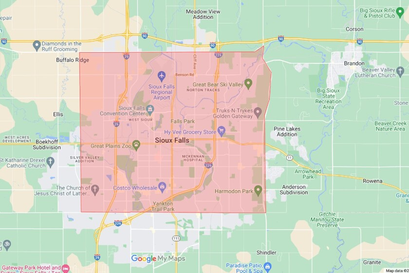
The red area above totals approximately 57 square miles, slightly larger than the California fires.
Mitchell
The City of Mitchell is made up of just over 11 square miles within city limits, meaning the fires would swallow the city five times over.
If the California fires were taking place in the Mitchell area, it would stretch from Spruce Street/255th Avenue to the Loomis-Plano Road and from the James River to 405th Avenue.
That land area includes Mitchell Tech, the Corn Palace, the Davison County Fairground, POET in Loomis, an eight-mile stretch as the crow flies of the James River and thousands of acres of farmland.
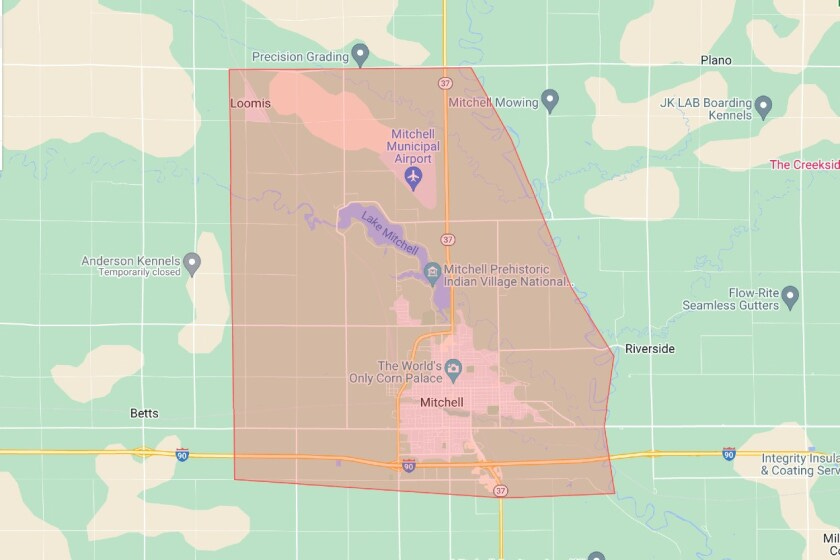
The red area above totals approximately 53.6 square miles, slightly smaller than the California fires.
Rapid City
The incorporated lands of Rapid City add up to almost the exact size of the California blaze — but fires don’t follow jurisdictional boundaries.
If the fires were burning in the Rapid City area, it would stretch from Bear Country to the Outdoor Campus and Interstate 90, over to the WaTiki Resort and down and around Rapid Valley and Green Valley.
In the danger zone would be all of downtown Rapid City, the Rushmore Mall, the National Guard base and the Monument.
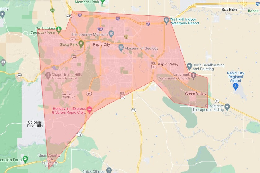
The red area above totals approximately 56.2 square miles, slightly larger than the California fires.
Help is on the way to California
With the destruction spanning such a large area, President Joe Biden approved a major disaster declaration for California on Wednesday, opening the door for affected communities to receive immediate and future assistance.
Further, California Gov. Gavin Newsom activated the state’s National Guard, while the federal government secured five U.S. Forest Service Large Air Tankers and 10 federal firefighting helicopters to support state and local firefighters.
Fire crews from across the country are also making their way to the Los Angeles area to offer their assistance.
Content courtesy of SiouxFallsLive.com.





Exceptional article, thanks for boldly reaching outside your normal contributors.
These fires command the news because the LA County population, 9.6+ million is larger than the population of a super-majority of US states. (Imagine pounding 9.6+ million in Minnehaha or Pennington County.)
'The problem' is local governments' addiction to permitting almost any development in the wildland-urban interface zone. Let's get accountable. Fires like these are the future of the Black Hills and many western communities. The Jasper fire was a remote wake-up call that is ignored by federal, state, and local governments. Since governments are incapable and unwilling to police the WUI developments or sustainable development it's incumbent on the insurance companies to police them - much as they are with selfish developments in hurricane prone zones and floodplains. One ought be all for 'freedom' to build on one's property - along with the 'freedom' to self-insure. It is not society's duty to save one from ones' selfish and bad judgment. No house, or life in a WUI or floodzone is worth the life of a firefighter or one tax payer dollar. My pines are little more than the potential energy of Roman candles awaiting a spark and wind.
Interesting and helpful comparisons. Thanks.